


Defiance, Williams, Henry & Paulding Counties PUMA, Ohio
About
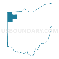
Outline

Summary
| Unique Area Identifier | 193687 |
| Name | Defiance, Williams, Henry & Paulding Counties PUMA |
| State | Ohio |
| Area (square miles) | 1,675.88 |
| Land Area (square miles) | 1,664.87 |
| Water Area (square miles) | 11.01 |
| % of Land Area | 99.34 |
| % of Water Area | 0.66 |
| Latitude of the Internal Point | 41.33388670 |
| Longtitude of the Internal Point | -84.43449070 |
Maps

Graphs
Select a template below for downloading or customizing gragh for Defiance, Williams, Henry & Paulding Counties PUMA, Ohio


Neighbors
Neighoring Public Use Microdata Area (by Name) Neighboring Public Use Microdata Area on the Map
- Allen County (Outside Fort Wayne City) PUMA, IN
- Auglaize, Mercer & Van Wert Counties PUMA, OH
- Hancock & Putnam Counties PUMA, OH
- Lenawee & Hillsdale Counties PUMA, MI
- Noble, DeKalb, LaGrange & Steuben Counties PUMA, IN
- Wood (South), Fulton & Lucas (Southwest) Counties--Bowling Green City PUMA, OH
Top 10 Neighboring County (by Population) Neighboring County on the Map
- Lucas County, OH (441,815)
- Allen County, IN (355,329)
- Wood County, OH (125,488)
- Hancock County, OH (74,782)
- Hillsdale County, MI (46,688)
- Fulton County, OH (42,698)
- DeKalb County, IN (42,223)
- Defiance County, OH (39,037)
- Williams County, OH (37,642)
- Putnam County, OH (34,499)
Top 10 Neighboring County Subdivision (by Population) Neighboring County Subdivision on the Map
- Defiance township, Defiance County, OH (13,178)
- Napoleon township, Henry County, OH (9,796)
- Clinton township, Fulton County, OH (9,554)
- Swan Creek township, Fulton County, OH (8,566)
- Bryan city, Williams County, OH (8,545)
- German township, Fulton County, OH (6,443)
- Noble township, Defiance County, OH (6,326)
- Hicksville township, Defiance County, OH (4,979)
- York township, Fulton County, OH (4,145)
- Montpelier village, Williams County, OH (4,072)
Top 10 Neighboring Place (by Population) Neighboring Place on the Map
- Defiance city, OH (16,494)
- Napoleon city, OH (8,749)
- Bryan city, OH (8,545)
- Archbold village, OH (4,346)
- Montpelier village, OH (4,072)
- Paulding village, OH (3,605)
- Hicksville village, OH (3,581)
- Edgerton village, OH (2,012)
- Deshler village, OH (1,799)
- Antwerp village, OH (1,736)
Top 10 Neighboring Unified School District (by Population) Neighboring Unified School District on the Map
- East Allen County Schools, IN (65,612)
- Bowling Green City School District, OH (35,618)
- Anthony Wayne Local School District, OH (27,810)
- Steuben County Metropolitan School District, IN (18,053)
- Defiance City School District, OH (16,675)
- Napoleon Area City School District, OH (14,482)
- Bryan City School District, OH (13,069)
- Wauseon Exempted Village School District, OH (10,371)
- Paulding Exempted Village School District, OH (10,261)
- Otsego Local School District, OH (9,825)
Top 10 Neighboring State Legislative District Lower Chamber (by Population) Neighboring State Legislative District Lower Chamber on the Map
- State House District 46, OH (127,690)
- State House District 6, OH (125,488)
- State House District 76, OH (120,854)
- State House District 74, OH (118,430)
- State House District 75, OH (112,019)
- State House District 58, MI (91,936)
- State House District 85, IN (78,990)
- State House District 51, IN (62,592)
- State House District 79, IN (62,178)
Top 10 Neighboring State Legislative District Upper Chamber (by Population) Neighboring State Legislative District Upper Chamber on the Map
- State Senate District 2, OH (363,296)
- State Senate District 1, OH (351,303)
- State Senate District 16, MI (253,123)
- State Senate District 14, IN (139,068)
Top 10 Neighboring 111th Congressional District (by Population) Neighboring 111th Congressional District on the Map
- Congressional District 3, IN (723,633)
- Congressional District 7, MI (676,899)
- Congressional District 6, IN (676,548)
- Congressional District 4, OH (632,771)
- Congressional District 5, OH (627,799)
Top 10 Neighboring Census Tract (by Population) Neighboring Census Tract on the Map
- Census Tract 3, Hancock County, OH (8,025)
- Census Tract 109, Allen County, IN (6,369)
- Census Tract 302, Putnam County, OH (5,823)
- Census Tract 3, Henry County, OH (5,209)
- Census Tract 9589, Defiance County, OH (5,109)
- Census Tract 307, Putnam County, OH (4,980)
- Census Tract 408, Fulton County, OH (4,940)
- Census Tract 405, Fulton County, OH (4,899)
- Census Tract 9506, Williams County, OH (4,828)
- Census Tract 403, Fulton County, OH (4,819)
Top 10 Neighboring 5-Digit ZIP Code Tabulation Area (by Population) Neighboring 5-Digit ZIP Code Tabulation Area on the Map
- 43512, OH (28,674)
- 46703, IN (18,029)
- 43506, OH (14,830)
- 43545, OH (14,034)
- 43558, OH (13,579)
- 43567, OH (13,283)
- 43515, OH (7,979)
- 43543, OH (7,771)
- 46737, IN (7,068)
- 43502, OH (6,933)